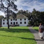
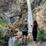
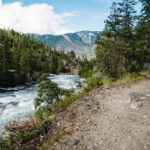
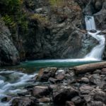
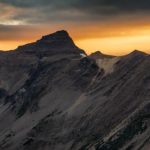
Leg 1

New Westminster to Hope

New Westminster

Located within the Traditional Territory of the Qayqayt Nation

Steeped in history of boom, bust, and revitalisation, New Westminster was the first stop on the mainland for miners to buy provisions and tools for their long journey ahead to …

Fort Langley National Historic Site

Located with the Traditional Territory of the Katzie, Kwantlen, and Matsqui Nations

Rising from the mist of the Fraser River, the walls of Fort Langley National Historic Site stand just as tall today. Discover the roots of this 1827 Hudson’s Bay Company …

Harrison Mills

Located within the Traditional Territory of the Sts’ailes Nation

Harrison Mills is located near the junction of the Harrison and Fraser rivers and surrounded by cascading mountain peaks. After the word got out that gold was discovered, in just …

Kilby Historic Site

Located within the Traditional Territory of the Sto:lo Nation

Located near the junction of the Harrison and Fraser Rivers, the Kilby Historic Site stands as the only reminder of the once thriving community of Harrison Mills. In November 1899, …

Hope

Located with the Traditional Territory of the Sto:lo Nation

For 10,000 years, Hope’s place at the confluence of the Fraser and Coquihalla rivers has made it a natural stopping point and meeting place for the Stó:lō (STOH-lo) Nation. European …

Leg 2

The Fraser Canyon-Hope through Lytton

Hope

Located with the Traditional Territory of the Sto:lo Nation

For 10,000 years, Hope’s place at the confluence of the Fraser and Coquihalla rivers has made it a natural stopping point and meeting place for the Stó:lō (STOH-lo) Nation. European …

Yale Historic Site

Located within the Traditional Territory of the Stó:lō Nation

Originally established in 1848 as a Hudson’s Bay Trading Post, the small town of Yale grew to an estimated 30,000 people during the 1858 gold rush; then the largest city …

Alexandra Bridge Provincial Park

Located within the Traditional Territory of the Nlaka'pamux Nation

Declared the “eighth wonder of the world” when it was completed in 1865, the waggon road played a key role in the gold rush economy of the 1860s, and in …

Hell’s Gate

Located with the Traditional Territory of the Nlaka'pamux Nation

Less than 2.5 hours from Vancouver is the deepest, most dangerous and fastest-moving section of the Fraser River; looking up you will see sheer rock faces and down below you …

Tuckkwiowhum Heritage Village

Located within the Traditional Territory of the Nlaka'pamux people

Tuckkwiowhum (Tuck-we-ohm) is located just 5 km south of Boston Bar and is a spectacular Nlaka’pamux (ing-khla-kap-muh) heritage site and village. The area was given its name by local Nlaka’pamux …

Boston Bar / North Bend

Located within the Traditional Territory of the Nlaka'pamux Nation

From Hell’s Gate travel north about 10 minutes on Highway 1 and you will arrive in Boston Bar, a town that got its name from the large number of gold-seeking …

Lytton

Located within the Traditional Territory of the Nlaka'pamux Nation

Located at the confluence of the Fraser River and its largest tributary, the Thompson River, Lytton has a dry climate with sagebrush growing in the hills and sweeping mountain and …

Leg 3
Northeast

Lytton to Spences Bridge to Historic Hat Creek

Lytton

Located within the Traditional Territory of the Nlaka'pamux Nation

Located at the confluence of the Fraser River and its largest tributary, the Thompson River, Lytton has a dry climate with sagebrush growing in the hills and sweeping mountain and …

Spences Bridge

Located within the Traditional Territory of the Nlaka'pamux Nation

Speculators first came to this area during the gold rush when the town was known as Cook’s Ferry. It is here that Cook and Kimble built a rope ferry across …

Ashcroft

Located within the Traditional Territory of the Nlaka'pamux Nation

Part of Nlaka’pamux (Ing-la-kap-ma) territory, the Indigenous people living in the area in the past and still today, rely on the bounty of fish in the Thompson River to sustain …

Cache Creek

Located with the Traditional Territory of the Secwépemc Nation

Set in a dramatic desert landscape and ideally located at the junction of Highways 1 and 97. Cache Creek has been a popular stopover point for travellers since the Gold …

Historic Hat Creek

Located within the Traditional Territory of the Secwépemc Nation

Ideally located at the junction of Highways 97 and 99, explore the original buildings used by gold rush travellers of the 1860s at one of the few original Cariboo waggon …

Leg 3
Northwest

Lytton to Lillooet to Historic Hat Creek

Lytton

Located within the Traditional Territory of the Nlaka'pamux Nation

Located at the confluence of the Fraser River and its largest tributary, the Thompson River, Lytton has a dry climate with sagebrush growing in the hills and sweeping mountain and …

Stein Valley Nlaka’pamux Heritage Park

Located within the Traditional Territory of the Nlaka'pamux Nation

The Stein Valley Nlaka’pamux Heritage Park contains spectacular scenery and significant historic, cultural and spiritual value. ‘Stein’ comes from the Nlaka’pamux (ing-khla-kap-muh) word “Stagyn”, meaning ‘hidden place’, referring to the …

Lillooet

Located within the Traditional Territory of the St'at'imc Nation

Lillooet is located at the foot of the Coast Mountain range with roads carved out of mountainsides and ever changing views of the Fraser River. The St’át’imc (STAH-tleum) Nation has …

Historic Hat Creek

Located within the Traditional Territory of the Secwépemc Nation

Ideally located at the junction of Highways 97 and 99, explore the original buildings used by gold rush travellers of the 1860s at one of the few original Cariboo waggon …

Leg 4
West

Lillooet to Bridge River Valley

Lillooet

Located within the Traditional Territory of the St'at'imc Nation

Lillooet is located at the foot of the Coast Mountain range with roads carved out of mountainsides and ever changing views of the Fraser River. The St’át’imc (STAH-tleum) Nation has …

Xwisten Experience Tours

Located within the Traditional Territory of the St'at'imc Nation

In the southern Chilcotin (chil-ko-tin), no fewer than 11 different communities make up the St’át’imc Nation, whose traditional territories were located in and around an ancient gathering place now known …

Seton Portage

Located within the Traditional Territory of the St'at'imc Nation

Once the site of a unique railway system, Seton Portage is a historic rural community located 25 km/15.5 mi by boat (78 km/48 mi by road over Mission Mountain) west …

Gold Bridge

Located within the Traditional Territory of the St'at'imc Nation

Nestled in the Bridge River Valley among the towering peaks of the South Chilcotin Mountains, Gold Bridge is located 105 km/65.2 mi west of Lillooet. This small town sprang to …

Bralorne

Located within the Traditional Territory of the St'at'imc Nation

Just 20 minutes south of Gold Bridge in the Bridge River Valley lies the community of Bralorne, which as a mining town during the Great Depression with the opening of …

Leg 5
East

Historic Hat Creek to McAbee Fossil Site to Logan Lake

Historic Hat Creek

Located within the Traditional Territory of the Secwépemc Nation

Ideally located at the junction of Highways 97 and 99, explore the original buildings used by gold rush travellers of the 1860s at one of the few original Cariboo waggon …

Cache Creek

Located with the Traditional Territory of the Secwépemc Nation

Set in a dramatic desert landscape and ideally located at the junction of Highways 1 and 97. Cache Creek has been a popular stopover point for travellers since the Gold …

McAbee Fosil Beds Heritage Site

Located within the Traditional Territory of the Secwépemc people

The McAbee Fossil Beds Heritage Site (now a cliff face) are part of a former lake bed that was deposited more than 50-million years ago. The area is located east …

Savona

Located within the Traditional Territory of the Secwépemc Nation

Savona is a small community located at the west end of Kamloops Lake on Highway 1 about 40 min from Kamloops with semi-arid grasslands and hills surrounding the area which support cattle …

Logan Lake

Located within the Traditional Territory of the Nlaka'pamux Nation

Logan Lake is a picturesque town located in the Highland Valley, surrounded by forested rolling hills punctuated by lakes and rivers. “Tslakan”, a Savona Indigenous fur trader, had a daughter …

Leg 6
North

Historic Hat Creek to Clinton to 150 Mile House

Historic Hat Creek

Located within the Traditional Territory of the Secwépemc Nation

Ideally located at the junction of Highways 97 and 99, explore the original buildings used by gold rush travellers of the 1860s at one of the few original Cariboo waggon …

Loon Lake

Located within the Traditional Territory of the Secwépemc Nation

Loon Lake offers an outdoor experience for the entire family, nestled between the Bonaparte Plateau and Arrowstone hills; this steep valley is home to many resorts, ranches and summer residences. …

Clinton

Located within the Traditional Territory of the Secwépemc Nation

The name Clinton was officially adopted on June 11th, 1863, replacing the previous name, “The Junction.” In the 1960s Clinton was an important roadhouse at the junction of the Cariboo …

70 Mile House

Located within the Traditional Territory of the Secwépemc Nation

Like other “mile houses” along the Cariboo Waggon Road, 70 Mile was a stopping house established in 1862 as a hostel for Cariboo Waggon Road work crews. The area has …

100 Mile House

Located within the Traditional Territory of the Secwépemc Nation

Located 100 miles from Lillooet on the original Cariboo Waggon Road, 100 Mile House was originally a Hudson’s Bay Company fur trading station, but by the early 1860s it became …

108 Mile Ranch and Heritage Site

Located within the Traditional Territory of the Secwépemc Nation

In the Cariboo’s 108 Mile Ranch, discover a close knit community complete with three lakes, a beautiful valley, bird sanctuary, resorts and an extensive 1500 acre greenbelt in a former …

Lac la Hache

Located within the Traditional Territory of the Secwépemc Nation

The village of Lac La Hache is often referred to as the Longest Town in the Cariboo, reflecting how its resorts, ranches, restaurants and vacation homes are scattered along the …

150 Mile House

Located within the Traditional Territory of the Secwépemc Nation

150 Mile House is a quiet ranchland community known for its gold rush, and pioneer history and log homes. The Cariboo Waggon Road was in fact scheduled to run through …

Leg 7
West

150 Mile House to Williams Lake to Quesnel to Barkerville

150 Mile House

Located within the Traditional Territory of the Secwépemc Nation

150 Mile House is a quiet ranchland community known for its gold rush, and pioneer history and log homes. The Cariboo Waggon Road was in fact scheduled to run through …

Williams Lake

Located within the Traditional Territory of the Secwépemc Nation

Named after Chief William, a Secwépemc (shi-HUEP-muh-k) chief from the area, the city is located at the junction of Highways 97 and 20, and has been one of the Cariboo …

Xat’sull Heritage Site

Located within the Traditional Territory of the Secwépemc Nation

The Xat’sull Heritage Site is a national award-winning heritage village located just 20 minutes north of Williams Lake on a grassy bench above the Fraser River. The Majestic Fraser River …

Soda Creek

Located within the Traditional Territory of the Secwépemc Nation

Soda Creek is a small community at the mouth of Soda Creek located just north of Williams Lake. Soda Creek was the terminus of the first sternwheeler steamboat in the …

Mcleese Lake

Located within the Traditional Territory of the Secwépemc Nation

The small community of McLeese Lake is a family vacation spot along the Cariboo Highway between Williams Lake and Quesnel and was formerly called Mud Lake. It was then renamed …

Quesnel

Located within the Traditional Territory of the Dakelh Nation

To the northeast of Quesnel, the Blackwater River is the eastern entry point of the Nuxalk-Carrier Grease Trail (Alexander Mackenzie Heritage Trail). Extending 420 km/261 mi westward to the Pacific …

Cottonwood House Historic Site

Located within the Traditional Territory of the Dakelh Nation

Cottonwood is located in the northern Cariboo Plateau, 8 km/5 mi northwest of Coldspring House, which is at the beginning of the Cottonwood River (at the confluence of the Swift …

Wells

Located within the Traditional Territory of the Dakelh and Secwépemc Nations

The mountain town of Wells was built as a company town for Fred Wells’ Gold Quartz Mine when the promise of more gold gave many an opportunity to escape the …

Barkerville Historic Town & Park

Located within the Traditional Territory of the Dakelh and Secwépemc Nations

You have reached the El Dorado of the gold rush, where on August 17, 1862 Billy Barker’s legendary gold strike on Williams Creek triggered a multi-billion-dollar industrial revolution that literally …

Leg 8
East

150 Mile House to Horsefly

150 Mile House

Located within the Traditional Territory of the Secwépemc Nation

150 Mile House is a quiet ranchland community known for its gold rush, and pioneer history and log homes. The Cariboo Waggon Road was in fact scheduled to run through …

Horsefly

Located within the Traditional Territory of the Secwépemc Nation

The first gold discovered in the Cariboo Gold Rush was on the Horsefly River in 1859, three years before Billy Barker made his big strike on Williams Creek. Legendary First …

Leg 8
Northeast

150 Mile House to Likely

150 Mile House

Located within the Traditional Territory of the Secwépemc Nation

150 Mile House is a quiet ranchland community known for its gold rush, and pioneer history and log homes. The Cariboo Waggon Road was in fact scheduled to run through …

Big Lake

Located within the Traditional Territory of the Secwépemc Nation

Stop at Big Lake Ranch, located on the shores of Big Lake, and follow in the footsteps of miners from around the world that searched for gold in the Cariboo. This …

Morehead Lake

Located within Traditional Territory of the Secwépemc Nation

Morehead Lake was created in the 1890s as one of the water supplies for the Bullion Pit Mine. According to some sources, the name “Morehead” came from the mining term …

Likely

Located within the Traditional Territory of the Secwépemc Nation

Likely is located on the original Gold Rush Trail at the west end of Quesnel Lake, the deepest fjord-lake in North America. This area played a significant role in the …

Leg 9

Gold Rush Circle Route

Likely

Located within the Traditional Territory of the Secwépemc Nation

Likely is located on the original Gold Rush Trail at the west end of Quesnel Lake, the deepest fjord-lake in North America. This area played a significant role in the …

Quesnelle Forks

Located within the Traditional Territory of the Secwépemc Nation

In the early 1860s, gold fever was rampant at the confluence of the Quesnel and Cariboo Rivers. ‘The Forks’ was established in 1859 and quickly became a rowdy camp and …

Keithley Creek

Located with the Traditional Territory of the Secwépemc Nation

One of the first big strikes in the Cariboo was made in 1860, when prospectors found gold at Keithley Creek. It was named after one of the prospectors William R. …

Cariboo Lake – Ladies Creek Rec Site

Located withing the Traditional Territory of the Secwépemc Nation

Cariboo Lake is situated about 24 km/14.9 mi north of Likely on the Keithley Creek Rd. It is large lake that is actually a wide swollen part of the Cariboo …

Cameron Ridge

Located within the Traditional Territory of the Secwépemc Nation

Cameron Ridge truly is a paradise, located in the heart of the Cariboo Mountains amongst the pines and spruce along a seasonal gravel road. The abundance of flowers, the diversity …

Ghost Lake – Cariboo Mountains Provincial Park

Located within the Traditional Territory of the Secwépemc Nation

Cariboo Mountains Provincial Park is true wilderness, dominated by rocky peaks, glaciers and densely forested valleys featuring plenty of lakes and lush wetlands. The park is situated in the interior …

Whiskey Flats

Located within the Traditional Territory of the Dakelh and Secwépemc Nation

Whiskey Flats was the site of a large early-century dredge operation near Wells and Barkerville. When standing on the shore, you can see the remains of the Kafue Dredge boat, …

Wells

Located within the Traditional Territory of the Dakelh and Secwépemc Nations

The mountain town of Wells was built as a company town for Fred Wells’ Gold Quartz Mine when the promise of more gold gave many an opportunity to escape the …

Barkerville Historic Town & Park

Located within the Traditional Territory of the Dakelh and Secwépemc Nations

You have reached the El Dorado of the gold rush, where on August 17, 1862 Billy Barker’s legendary gold strike on Williams Creek triggered a multi-billion-dollar industrial revolution that literally …

Cottonwood House Historic Site

Located within the Traditional Territory of the Dakelh Nation

Cottonwood is located in the northern Cariboo Plateau, 8 km/5 mi northwest of Coldspring House, which is at the beginning of the Cottonwood River (at the confluence of the Swift …

Leg 10

Barkerville to Wells to Bowron Lake

Wells

Located within the Traditional Territory of the Dakelh and Secwépemc Nations

The mountain town of Wells was built as a company town for Fred Wells’ Gold Quartz Mine when the promise of more gold gave many an opportunity to escape the …

Barkerville Historic Town & Park

Located within the Traditional Territory of the Dakelh and Secwépemc Nations

You have reached the El Dorado of the gold rush, where on August 17, 1862 Billy Barker’s legendary gold strike on Williams Creek triggered a multi-billion-dollar industrial revolution that literally …

Bowron Lake Provincial Park

Located within the Traditional Territory of the Secwépemc and Dakelh Nations

Bowron Lake Provincial Park is a large wilderness area situated on the western slopes of the Cariboo Mountain Range. The world-renowned Bowron Lake Canoe Circuit encompasses a 116 km/72 mi chain …